

|
|
What a start to 2013 here in N. Ireland for exciting Winter weather. During January I was surprised by the amount of local Winter 'chases' I did with almost back to back drives up the mountain in severe conditions and during that period I got treated to snow storms, blizzard conditions, massive icicles, rime ice, snow drifts and just when I thought the action was over the Atlantic came back with a succession of deep low pressure storms which delivered gales, heavy rain, and big waves not to mention a chance of flooding from melted snow. As the month came to a close a cold front rushed in from the Atlantic once again forming a severe squall line which crossed over Ireland from SW to NE producing a stunning night time lightning display across S and E parts of the country and although it never made it into N. Ireland the reports down south and the radar watching were exciting enough on their own, it was quite obvious from the sferics and reports that it was an epic event for this time of year, I for one cannot recall such a significant inland lightning event during January since I first got into this fascinating field. Eye witnesses reported house-shaking thunder and crawler lightning with some even going so far to say that they hadn't seen anything like it since the 1980s, at one stage there was even a strong rotation signature on the radar near Dublin which indicated a risk of tornadoes.
 |
The following morning, January 31st introduced a very unstable air mass around coastal areas in the wake of the overnight squall line with a further risk of squally showers and thunder in a sheared atmosphere however I didn't pay it much attention as all the action would be on the W coast and I suspected that any cells would be unlikely to survive their passage inland so I got on with other things. However it wasn't long before my attention would once again be turned to the weather when I got several excited text messages from Omagh storm chaser Paul Martin reporting thunder and flashes of lightning in his area, I quickly went online and checked the radar and saw that the culprit cell was moving E well inland and was already over the Sperrin Mountains and making swift movement in my direction and judging by the extent of its radar echo it must have been near the length of Ulster in size. I looked out my front door facing W and saw the leading edge of the cell heading for my estate with nasty black clouds rushing in so I ran upstairs to get my camera gear. At this point I heard a sudden rush of air accompanied by rumbles and bangs then looked out my window to the E and saw that the cell had produced a violent downdraught in the form of horizontal straight line winds (SLW) which blew the rain and hail stones across the road in such a way as if it was forced by some magnificent power hose. Wheely bins blew over and where pushed across the street, one even blew into the side of my car, then the cell passed into the E and behind it was a brutal looking dark anvil with widespread mammatus display showing off just as the dark skies retreated and sunshine returned, it had all happened in seconds but it was an impressive squall event and a very exciting way to end the month.
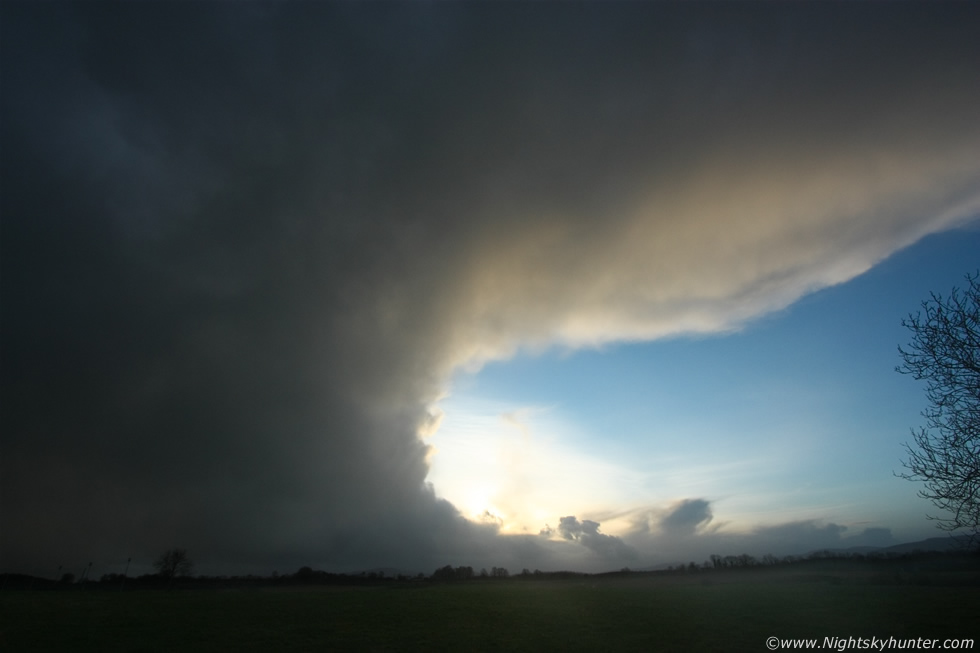
During the late afternoon I was on the road with my Mother doing a message to Magherafelt and one the way back we ended up going on an unexpected local storm chase. We where positioned in the countryside near Gulladuff and had been driving through narrow back roads tracking a large cell which looked pure black heading our way from the W, we had to keep trying new roads as we tried to position ourselves in such a way that the cell was going to pass near us but not over us as I wanted to check out the structure and hoped that a mammatus display would unfurl. We picked a better road and when the timing seemed rite I pulled onto a grass verge near a grand looking house which looked more like a mansion, so we stayed here to watch which provided is with a great view towards the cell over miles of flat fields. Above was the cell as it passed close by us backlit by the sun with sun rays breaking out at the rear, it was moving from R to L and looked awesome, this was taken at 10mm wide angle and yet it didn't even fit the entire anvil in the frame. The straight back edge of the updraught as it curved upward into the anvil looked quite incredible, I was shocked by such quality convection for January, in fact, this looked more like a high quality Summer thunderstorm in a 1000 CAPE environment, this just goes to show what really cold air aloft can do in the Winter months when you are surrounded by a warmer Ocean.
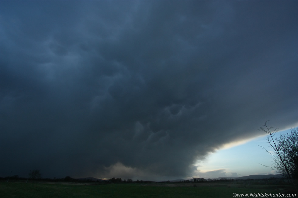 |
The same cell a little later just before the sun set at 10mm ultra wide again. My mum was even impressed by these clouds and it normally takes alot to impress her. A nice display of mammatus covered the entire underside of the huge anvil, this lens is so wide it you can cover 107 degrees of sky in a horizontal direction, its fantastic for covering huge areas of sky however it has a tendency to make subjects look smaller and further away than they actually where at the time, so just to point out that the mammatus and anvil where actually over our heads at this point and beyond the frame!. The precip core which sported a squall of hail and rain can be seen to the L.
Video clip showing the squall over Maghera earlier in the day followed by the Gulladuff cell heading in over the fields. What a way to end January and I wondered as the sun set on another freezing night if February would be as good and to tell you the truth my instincts told me it would, and much to my surprise the weather would go crazy again in just four days time.
On february 4th I was in Belfast for the weekend with Roisin enjoying a break from chasing weather and doing normal things for a while when suddenly my period of relaxation came into an end when I picked up on some chat regarding a significant Winter weather event due to happen in a matter of hours. It was a Monday afternoon so we went to the library and booked a computer where we spent some time going over the charts and talk on the forums and by the time I had finished I knew I would be leaving Belfast as soon as I could. A very deep low pressure system was passing to the NW of N. Ireland bring several very active troughs across the ocean to our shores during the evening and overnight hours combined with very strong winds which could reach storm force at the coast combined with frigid air aloft and up to 400 CAPE and LIs of -1 over the N and NW coasts and quite far inland too during Monday evening. To cut a long story short there was a good chance of a notable snow event and blizzards even on lower ground and the unstable air would form showers and thunderstorms after dark with a good chance of thundersnow. Severe weather warnings were going out from every source for snow, blizzards, thunder, and for the first time ever I read that their was a 'significant risk to livestock' on exposed hills so this had all the hallmarks of a major event.
 |
I needed to get home to Maghera asap and since I knew I would be in for a cold brutal night I stayed a little while longer to eat and Roisin made me one of her delicious hot stews then within the hour I was on the bus heading home and by 19.00 I was back in Maghera where heavy snow was already falling, it looked like the action had begun already. I just had time to drink a quick cup of tea and sort out my clothing then I was getting in the car for 19.30 and for some reason my Mother had insisted on coming along with me, she said she was concerned for my safety and wanted to be with me however I suspect she wanted to enjoy the excitement of the weather and the unknown which lay ahead so I had no quarrels with that so the two of us began the drive N through very heavy blowing snow which showed no signs of stopping and with hours of the stuff to come who knew what could happen later, mum Mum said ''this is crazy'', and I just smiled.
We spent hours along the Co. Antrim coast during the peak of the storm. We stopped in Portrush to get a chicken nugget and chip between us to warm up and when we came out from the shop we were shocked to see the entire street covered in white hail stones, and I mean covered, like a layer of thick snow, that must have been one heck of a hail storm. We spent some time at the Giant's Causeway then I settled at this location on high ground near Portrush looking NW across the Atlantic Ocean. I got very little photography done during the entire session simply because the conditions were so severe, the wind was too strong for setting up a camera on a tripod and even the car was rocking on its suspension and furthermore for the first half of the night we didn't get a break in the storm, I knew there where many cells over the ocean coming in however I had anticipated clear skies between them for photography but we never got any as it was constantly blowing snow at us the entire time. This period was quite epic to be honest and there's no way I can do it justice with words or with images.
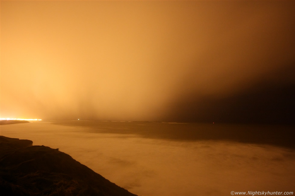
Being near the ocean can bring a mix of extremes with milder air clashing with cold air which is why coastal areas are more unstable and storm savoy during the Autumn and Winter months. I did manage to get a few exposures, the above was a massive squall of snow falling over the sea heading straight for the camera which had arrived from Donegal direction, again this was at 10mm ultra wide so it was huge in reality. The street lights made the snow and clouds orange in the exposure however visually they were a ghostly pale white colour, the snow curtains were huge and looked amazing as they fell on the sea in graceful curves of mottled structure, the entire structures actually looked very intimidating as they approached. I managed perhaps three exposures before it hit us, I had to grab the camera strap and pull it down hard while holding the tripod to stop it blowing over, this combined with the icy wind cutting through my clothes into my legs and stinging snow in my eyes made for a very challenging shoot. When the squall arrived our mouths dropped with awe as we got treated to a full on battering of sideways snow, hail, and sea foam all combined in one icy mix. The snow flakes were huge and the lumps of foam were stupendous in size like white irregular canon balls whacking against the windows with a slap, it was very exciting to watch.
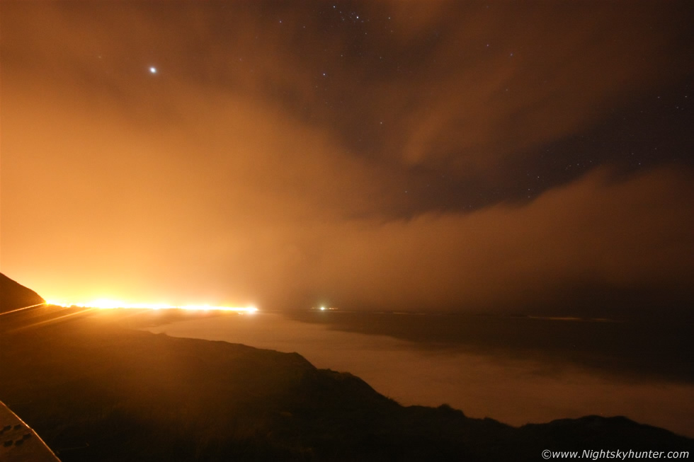 |
Squall after squall hit with snow, hail, and foam being a part of our lives at this stage. While taking shelter in the car and having no internet I needed to know the bigger picture so I text Paul again for some advice on the situation. Paul informed me that there where cells all over the place with recent lightning near Fermanagh and thundersnow reports from Derry City so we decided to stay a little longer to see what happened. We got a brief clearance so I took this exposure looking NW to W, the R side would be Donegal direction and left in the general direction of Derry where that thundersnow had been reported, Paul said there was a massive cell there moving E/SE so perhaps I got a hint of it on this image, all the cloud there below Jupiter was probably associated with that cell however it never cleared properly and the snow returned once more so I couldn't get the structure shots I had been hoping for. Check out that big arm of cloud moving towards us, you would think that looked harmless enough, well that's what I thought until it hit.
 |
It must have intensified rapidly from sea to land for it produced another severe squall with snow flakes assaulting the area. I parked the car above White Rocks Beach and used the full headlight beams to illuminate the road signs and pick up the blowing snow which I then filmed with my camcorder, this is a still from that video footage.
Video clip of that snow squall near the signs. Remember this is night time with a normal video camera so most of the snow doesn't show up and the frame rate doesn't match the speed as seen with the naked eye so the real scene was much more dramatic than this however I hope the clip gives an indication of what conditions were like this night. One memory from this night really stands out to me and is something I couldn't photograph however it's worth mentioning. We drove into Portstewart, and as any local reader will know the harbour their is famous for its blow hole in stormy conditions, well the scene here after midnight was absolutely surreal with enormous waves breaking over the walls of the harbour and crashing on top of the boats accompanied by loud bangs and roars with the moored boats moving upward then down rapidly with the deep swell which surged into the bay, it was so random that it was truly frightening to watch, it seemed like a tsunami at times with horrific areas of strong rotation as the sea pulled back then whipped forward with jets of water and curling breakers hammering the stone work, the visual scene at this time of night under the subdued street lights with Jupiter and the Pleiades above was a sobering experience, it was amazing, thrilling, exciting but it would be enough to put one off ever going on the ocean again, a true reminder that nature is always in charge and you don't want to be on it when she's in a bad mood. It was a arduous night with some epic scenes with more fuel expense and safety concerns on the roads and a risk to health being out in such severe cold conditions and to think that I only came home with two images seems hilarious now however the trip was worth it for the new memories and I think it opened my Mother's eyes to the kind of stuff I do. When you tell people of the things you have seen in the sky and weather events you have experienced they tend to listen with interest and brush it off, however if you are actually there with me when its happening then reality really hits home!
 |
We made it home to Maghera at 01.30 however driving home was an adventure in itself. The roads were covered in thick snow all the way with not a gritter or plough in sight and even if they had been out earlier their work would have been in vane due to the intensity of the snow which was falling, it never let up, it was thick, heavy and blowing sideways with low visibility and it was difficult to tell where the road ended and the ditch began while all the time the car would periodically slide so it was a slow drive back, there was only one other car on the road the entire time in front of us and I was grateful it was there for I could see the rear lights through the blizzard which gave me some idea of where I was on the road but even those lights slid wildly from time to time too. Back at home I spent until 03.00 watching the snow fall over our estate below the streetlights making wonderful dancing movements all cast in soft orange which was a peaceful way to end the night. I was tired, cold and needed sleep, Paul was texting me about more lightning flashes he could see from Omagh from more thundersnow storms however my computer was closed down so I couldn't get access to the radar for another chase so I decided to call it a night and get some rest, the last thing I thought before sleepsville arrived was if conditions were that bad at the coast then they must have been insane on Glenshane Pass so I decided to get up early the following morning and check it out.
 |
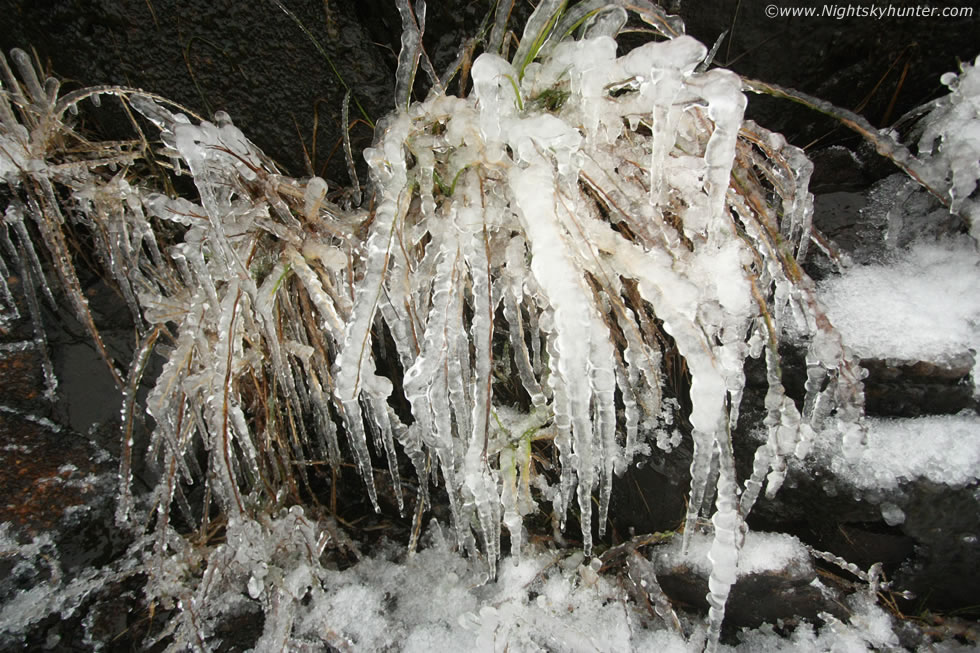
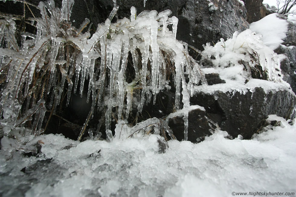
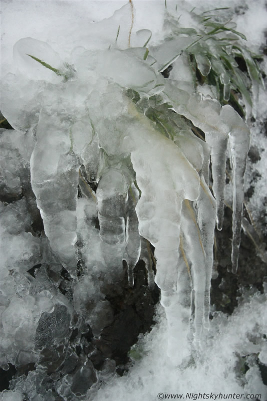
Up early on the 5th to see what happened on Glenshane during the previous night's madness. I suspected after a night of constant heavy snow, squalls, followed by a pre-dawn clearance and severe drop in temp there could be something cool (excuse the pun) to photograph. I made it to the top of Glenshane and as expected there was snow however what I wasn't expecting was this. The walls and cliffs which line the main road where covered with icicles, this was shocking because the same thing had happened only 14 days earlier (report), to see an ice event so soon in the same place was shocking and a true indicator of the severe conditions which took place here during the night. I pulled the car over and got out for a closer examination, although there where hundreds of icicles in the 1 to 1.5ft range what made this event different from the previous formations which were much larger in size was the degree of glaze ice covering everything. Running water coming down the mountain and the numerous waterfalls there produced this display, it seemed everything was covered in thick clear ice. This large grass bush looked incredible incased in thick ice.
 |
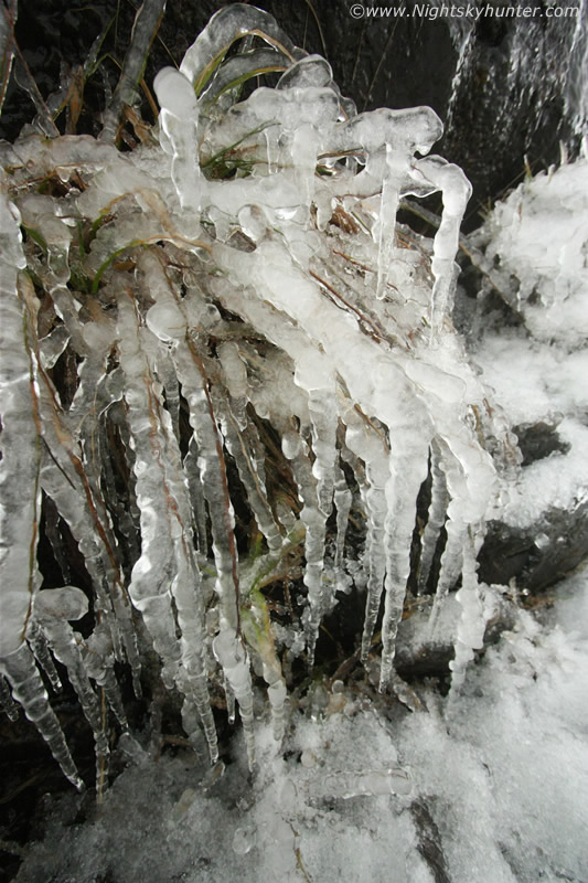
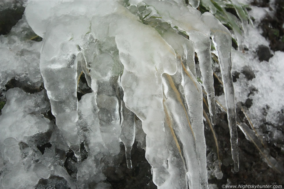
These were with the 10-22mm up close and I can tell you it was a very difficult shoot and just as difficult to keep a steady hand as the temps were freezing with a bone chilling breeze with periodic snow flurries, however what made this formation particularly challenging was the fact that a waterfall was beside me so I was bending down shooting the scene with my back getting sprayed constantly by cold water, my clothes were soaked and my camera was covered in water. Nature really knows how to making dramatic scenes, when I showed these images to Roisin she said they reminded her of an ice crystal chandelier. I could have done with the lens stopped down to get more depth however the light was low and I was freezing and tired so I had to do the best I could under the circumstances.
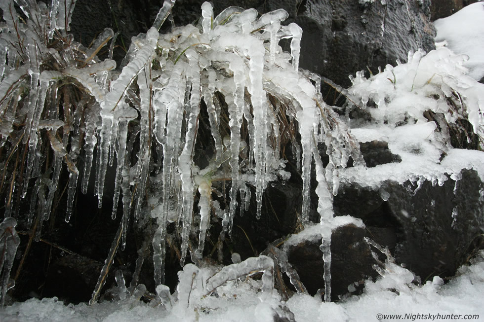 |
This is called clear ice or glaze ice and to get it with this kind of thickness and so widespread is indicative of very severe conditions, having a source of dripping or running water helps however you need the really low temps to freeze the moving water. The previous icicle display here formed after four days during a nasty cold spell in January so freezing, melting, and refreezing can happen which generates large icicles, however this event happened literally overnight so that takes some doing. I was impressed by just how much ice there was, on the grass, bushes, hanging from rocks, on both vertical and horizontal surfaces, I was blown away by the show to be honest.
 |
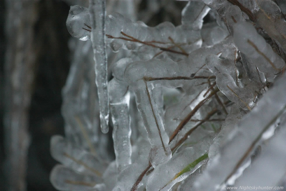
This one reminded me of an ice Tarantula Spider. Check out the blade of brown grass on the far L with thick ice all around it.
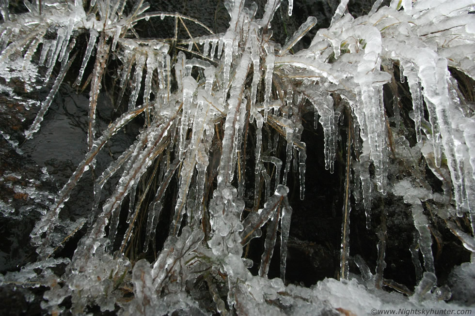 |
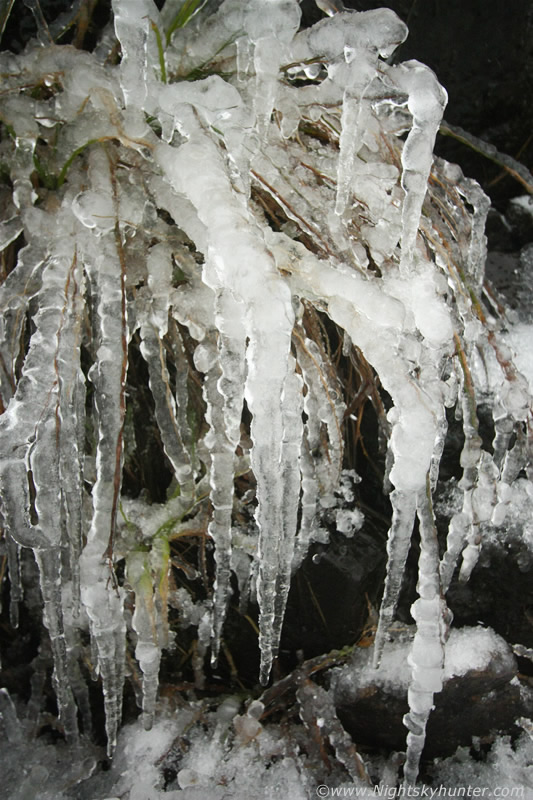
Of note are the trains of globular ice bumps covering all the crass which indicated that the freezing event took place during a period of irregular movement with dripping water, no doubt caused by the uneven surface of the grass stalks.
 |
If you watch the video below you can hear the sound of the waterfall and spraying water droplets which was a nightmare to shoot under and not good for your health either in such cold conditions so I took off the Canon 10-22mm and replaced it with the 100-400mm and backed away, this way instead of freezing low to the ground with macro-type shots I could get some distance away from the waterfall then zoom in close with the telephoto for some respite. It varied from a good inch to inch and a half of clear ice all around these grass blades, as you can see some of them have snapped under the weight of the ice.
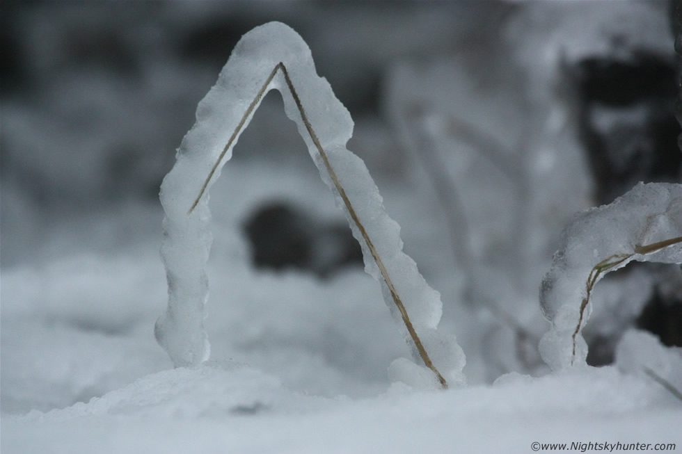 |
This isolated stalk looked so cool on its own jutting out from the ice pack totally incased in ice to the extent that the blade broke in the middle. I found that to photograph ice one had to be careful with the exposure settings because even a slight over exposure or too much ISO would make the ice look white like snow with slight underexposure producing the clear ice effect however in this case the scene looked too dark so I had to compensate for that by using a higher ISO, but take my word for it that this was crystal clear.
 |
I drove several hundred meters down the road following the mountain edge and stopped for another random check, I hiked up a steep tractor path which was fast turning to mud as a thaw began then I discovered more amazing ice formations so the 10mm was back out. I was standing half way up a steep mud bank to get these with my boots constantly sliding down so it was difficult to get close and keep purchase to get shots before sliding back down to the path.
 |
I didn't have my tape measure with me but these must have easily been 3" thick in places
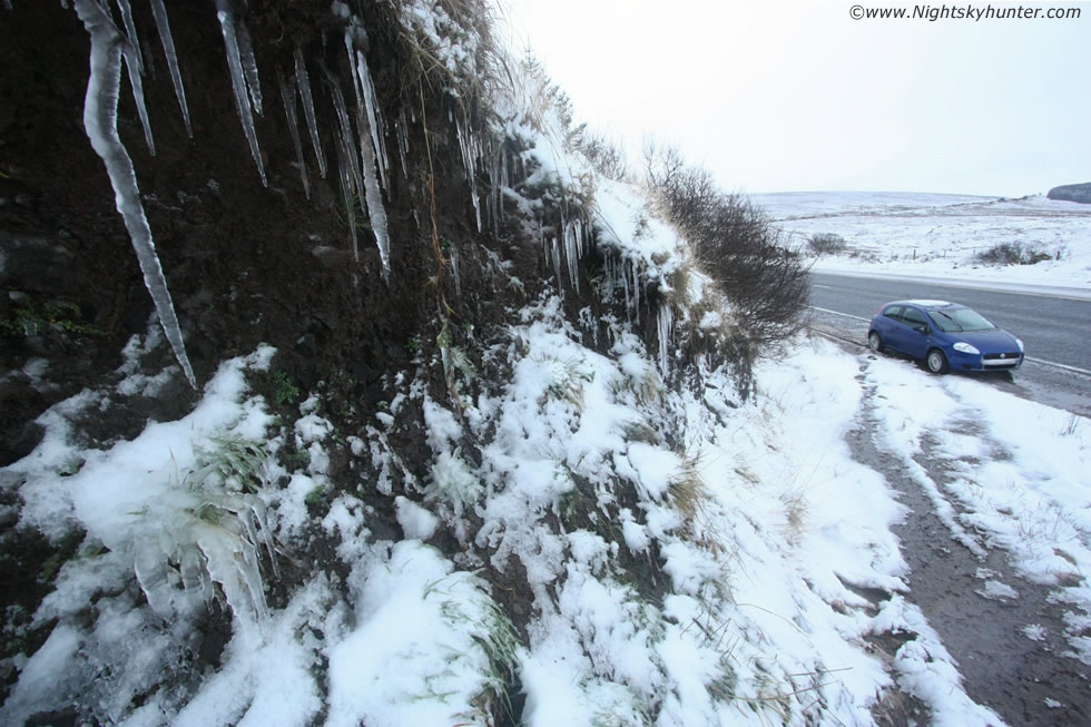 |
Ultra wide shot of some of the icicles with the car for a sense of scale. I was feeling tired, very cold and thirsty however I was glad I had sacrificed much sleep and got up on the mountain nice and early for the thaw would melt everything here within a few hours so talk about good timing.
Video clip of the icicles and glaze ice, listen out for the waterfall, you can see it at one stage and think of what it would be like to have that hitting your back in freezing conditions while trying to do photography!. Even as I write this I still can't believe I have witnessed two major ice events here within a two week period, Glenshane Pass and the Sperrins really is the place to be for severe Winter scenes.
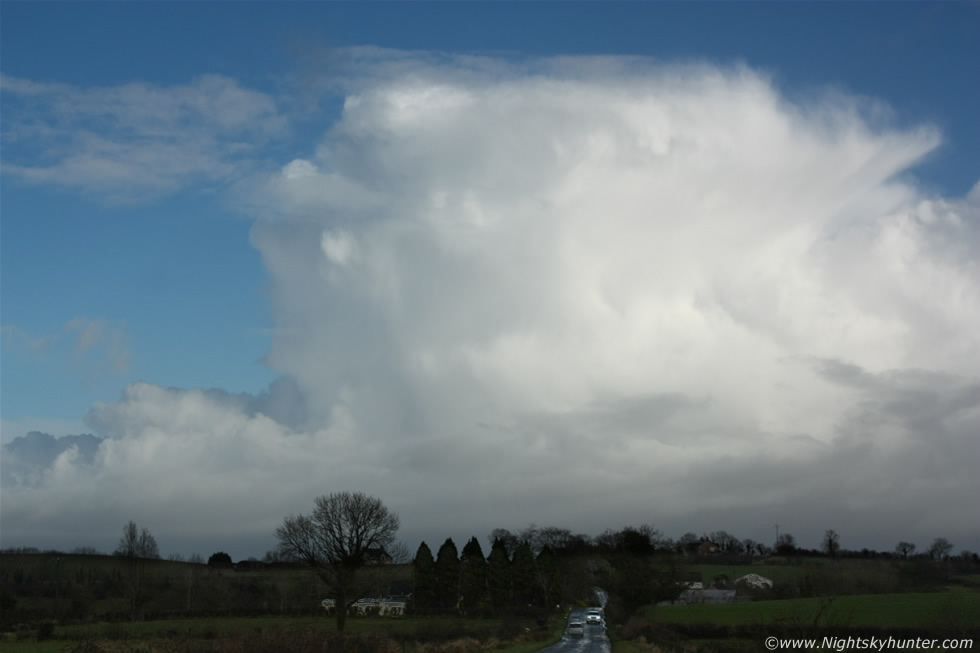 |
With hardly any sleep I went back home and changed by wet clothes and got a warm lunch and was getting ready to drive to Magherafelt to leave my computer in. For reasons I won't get into my computer needed formatted so I had it disconnected the previous night all ready to go and because of this I wasn't on the internet to know what kind of weather set-up was going on today however after the ice formations and the start of a thaw I figured the best was done until 13.00 when I looked out my bedroom window and saw an impressive line of convection towering high above the neighbours rooftops so I got in the car and drove swiftly to the bottom of the road to check out the scene with just half an hour until my appointment to sort out the computer. This image doesn't do the scene justice at all but I can tell you that the N to NE skyline was a place of pure beauty. Three large cells in a row where growing rapidly along the NE side of N. Ireland over Cusendall and Cusendun direction heading further inland, they had previously exploded to life over the warmer more unstable North Channel which was obviously a place with unstable air, cold air aloft, and convergence. The sun turned the row pure white against a crisp cold Winter sky and a proud anvil formed with some mammatus, these where thundersnow storms, or thunderstorms with snow, later checks showed several c-g lightning plots near the NE coast.
Here's a video clip which should do the scene more justice. To see these anvil tops so large and well defined from Maghera as they came inland indicated that they must have been very big cbs, I was once again impressed by the sight, was this feb?. The back end, moving L to R, was quite vertical with a small flanking line and as the cells moved further S their anvils became very well sheared downwind so they were organized for a time, I wondered if there had been any funnels or waterspouts over the coast during this period, however no reports have appeared since. What you can't see on the images and video but what struck me most with the naked eye was the strong perception that these cells were extremely glaciated, we all know that thunderstoms have ice inside however these thundersnow cells seemed to be made of ice and snow in a very obvious sense, it seemed like watching a mountain of icing shaped like an anvil. I could see the snow falling over land beneath however I never got to hear the thunder at this range, but even seeing the cell itself is just as special. Thundersnow is rare, N. Ireland gets one or two isolated events every Winter but you need to be lucky to be in the rite place at the rite time to experience it, and once you do you will never forget it!. What an exciting number of days - snow, blizzards, lightning, thundersnow, ice formations, convection and much more. 2013 is already turning into an exciting year and I'm already anticipating what wonders await during Spring and Summer. Thanks very much for reading.
Martin McKenna